
Announcements
Announcements
A new journal article published in PLOS Water highlights a novel tool by SEI called Aquatic Habitat Assessment (AHA), developed to assist a California water district in balancing the water supply needs of critical fish species and humans alike in the Silicon Valley technology hub.
Co-lead author and SEI Scientist Doug Chalmers explains how AHA came to be and its potential for addressing human-versus-habitat water conflicts throughout the world.
Photo: Supercaliphotolistic / Getty Images
The catalyst for this research began with a complaint against a California water district. Can you tell us about that?
For a long time, the Santa Clara Valley Water District operated its reservoirs and water system to prioritize meeting local water supply for municipal and surrounding agriculture use, as well as to replenish local aquifers. They were also meeting a handful of minimum California Fish & Wildlife requirements for leaving water in-stream for fish habitat.
But local fisheries interest groups believed that the terms of their water right license should hold them responsible for doing more to protect local aquatic species, including steelhead and salmon, based on the public trust doctrine and several state regulations. They sued the water district in 1996. After several years, parties reached the 2003 Fisheries and Habitat Collaborative Effort (FAHCE) Settlement Agreement, which required the utility to change its operations to balance protecting aquatic habitat with its existing human supply and groundwater recharge goals.
SEI became involved in 2016 to help evaluate the impact of the initial operation rules specified in the settlement, as well as help the utility (known as Valley Water) and the Technical Working Group involved in the settlement revise and develop an optimized set of operation rules.
Can you tell us about the Santa Clara Valley Water District and the bodies of water it covers?
Valley Water’s service area encompasses Santa Clara County, surrounding the City of San Jose and serving 15 cities and 2 million residents considered part of the Silicon Valley technology hub.
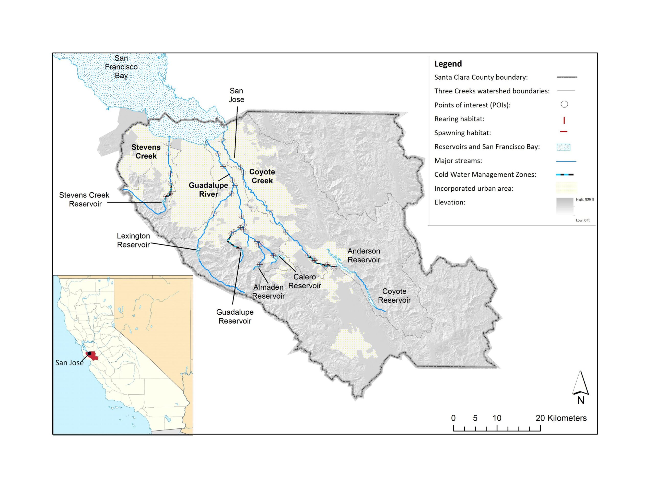
In this project, we primarily considered the watershed of what we call the “Three Creeks,” consisting of the Guadalupe River and its tributaries, Coyote Creek and Stevens Creek. The creeks run from south to north from the hillsides surrounding San Jose into the southern portion of the San Francisco Bay. The Guadalupe River runs right through downtown San Jose. Coyote Creek is along the eastern edge of the urban area and Stevens Creek runs west of San Jose through the town of Mountain View – if you’re in the area, you may see a lot of cars sold from here bearing the name “Stevens Creek.”
The reservoirs and the creeks provide a lot of local park space and water access for the folks in the county. Water supply is provided by local water stored in the reservoirs on the three creeks, supplemented with imported water originating in the Sierra Nevada mountains. Local water use in Santa Clara County consists of municipal and industrial use in the urban areas, groundwater recharge in the valley, and agricultural use in the areas to the southeast of San Jose, including Gilroy, home to the Gilroy Garlic Festival.
You focused on two species: Chinook salmon and steelhead trout. Why is that?
Protecting these two species was defined in the Settlement Agreement. They warrant special attention because of their vulnerable condition and importance in the ecosystem, as well as for fisheries in cultures across California. The local population of central California coast steelhead trout were listed as threatened in the federal Endangered Species Act, which helped push the Settlement Agreement forward, while the local Central Valley fall-run Chinook are a federal and state Species of Special Concern, with both populations having estimated to be at or below 10% of their historical abundance. The solutions to protect their habitat – namely, partially restoring the natural, seasonal flow pattern – help protect a wider variety of native species. However, some scientists claim that habitat restoration is overly focused on salmonids, at the expense of insects and other fish species.
Map of Santa Clara County, California, and the Three Creeks Watershed. Image: Doug Chalmers and Valley Water
The model connected to the tool helps guide the conversations toward the answer, rather than directly being the answer itself.
Doug Chalmers
You used a tool developed by SEI called Aquatic Habitat Assessment – what does it measure and how does it improve upon previous tools and approaches to assess aquatic habitat?
The Aquatic Habitat Assessment helps answer the question: How suitable is the stream for the fish species in each of their life stages, from laying eggs, to growing up, to traveling in and out of the stream? We developed the tool specially for this project to help explore how changes in the reservoir operations impact the habitat of the species.
The tool does three things all together: (1) it looks at the whole watershed, (2) provides detailed estimates of habitat suitability for the fish, and (3) it considers dynamic operations which change based on seasonal inflows and demands.
A number of studies have looked at one or two of these, but this was one of the only studies out there that explored all three of these things at once.
Your ultimate goal in this collaboration was to achieve “functional flows” – what does that mean?
Our ultimate goal was to help design reservoir operations which better protect habitat while balancing this with the existing goals of groundwater recharge and human water supply. This aim closely resembles a term coined by researchers across California called “functional flows,” which is an acknowledgement that we are living in a developed state with established human demands for water but aspires to provide streamflow which at least provides the basic elements of the natural flow regime which species need to survive and have adapted to. That includes high streamflow and storm pulses during the wet winter, dry summers, and a spring transition period.
So that’s what we did here – we still have reservoirs and are meeting our local human supply, but we tried to minimize the impact to these things while still doing much better to provide higher winter flows and storm pulses consistent with the natural Mediterranean seasonal climate of California.
Feature / SEI's flagship water modelling tool helped a San Jose-area water district identify an opportunity to help protected steelhead in the wake of dam construction.
You ran a set of scenarios using AHA for how water allocation and operations might operate in the future, weighing the trade-offs of each. What did you discover and how did the negotiating parties respond?
Trade-offs is the name of the game. Water often has zero-sum tradeoffs, meaning that there is a set amount of water and if you use it for one thing, then you are taking away from something else. The experts involved ended up prioritizing more frequent pulse flows which provide signals and help the fish move between the ocean and the streams, and providing them in a greater number of years, even during a dry spell, to help give the salmon opportunities to reproduce and spawn more frequently, which perhaps is the most critical element now under the current operations.
But, given the variability in the amount of rainfall in California from year to year, and considering that we are near the southern extent of the Chinook salmon’s range, there really wasn’t a whole lot of water supply that we can do much with during some of the dry years.
Of course, the technical solutions are always the easiest part of the process. Given the nature of this project stemming from a lawsuit, there was a fair amount of animosity and mistrust between parties. I would say that this project improved relations, but didn’t resolve everything, of course. While not everyone was satisfied, we were nonetheless able to advance a prescribed set of operations which are now being used as pilot operations in some of the watersheds. So that has been a long time coming, and satisfying, especially given that the complaints were first lodged in the ‘90s.
How can this approach be replicated in other watersheds? What would that mean for sustainable water management?
The human and technical challenges are hardly unique to this watershed. They are relevant across the western US, and other regions around the world with water scarcity and conflict over competing local water uses. Our tool and processes can help look at the whole watershed, with enough details to hone in on the habitat needs of the fish during each of its distinct life stages, and effectively model the tradeoffs of habitat and water supply together.
We take an approach that the model connected to the tool helps guide the conversations toward the answer, rather than directly being the answer itself – so you take the information our tool produces to inform these conversations, and then that’s where the really hard work happens to come to a consensus on how to manage the watershed.
But, if you can manage to get folks to agree, even perhaps reluctantly, on a solution that better balances, maybe imperfectly, the competing uses for water, we can approach a global balance of better protecting our aquatic species while still maintaining water security and livelihoods for agriculture and domestic use.
Journal article / Researchers used a suite of tools to model human and aquatic habitat water needs in a California watershed and aid local water allocation policy.
Project / SEI adapted WEAP to assess the needs of chinook salmon and steelhead trout in the Santa Clara Valley Water District.
Project / SEI researchers work throughout California to model complex water systems and explore sustainable management options.
SEI brief / Policy-makers can now model the effect of management options on the availability of habitat and the viability of aquatic species.
Feature / SEI Senior Scientist Chuck A. Young explains why California saw severe water shortages this year and how better forecasting can help alleviate those challenges.
Feature / The eWRIMS Analyzer transforms California’s water rights data into accessible reports on monthly water use in each watershed.
Design and development by Soapbox.