
Announcements
Announcements
Flash floods in the northern mountains along the Thailand-Myanmar border result in loss of life and damage to property and livelihoods every year. SEI Asia is working with local communities and state officials to assess and reduce the risks of flash floods.
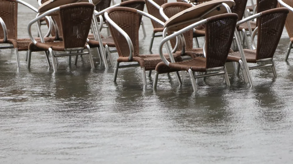
In October 2021, flash floods damaged the market in Mae Sai district along the Thailand-Myanmar border.
Photo: DDPM.
In the early morning of 31 October 2021, flash floods triggered by heavy rains swept through the Sai-Ruak River Basin, a transboundary basin along the Thailand-Myanmar border in Mae Sai District of Chiang Rai Province in northern Thailand. The floods caused more than THB 17 million worth of economic damage.
Continuous heavy rains in mountainous terrains usually result in flooding and mudslides that can result in loss of lives and property as well as blocking and damaging roads and communication networks. The sudden nature of flash floods gives very little time for people to evacuate from the area. The Sai-Ruak River has faced many such flash flood events in recent years.
In the last seven years, severe flash floods occurred twice in this river basin, which resulted in significant economic damages and inundation. In 2021, floods covered the two kilometers of river at the northern border of Thailand with Myanmar.
Before and after the floods: The river in Mae Sai district on 31 October (left) and 1 November 2021 (right).
Photos: DDPM
Given the frequent occurrence of flashfloods in Mae Sai, most people have accepted that floods are a part of their lives.
The local communities have put in place several measures to cope with flooding. Many families store their perishables, goods and electronic equipment on higher floors or elevated platforms during the flood season, which is usually from July–October. Some concrete houses have also installed metal gates to prevent floodwater from entering through the doors. In many places, sandbags are placed at the expected entry points of floods, especially near the banks of the rivers and streams to prevent overflow of waters. During periods of continuous rainfall of more than two days, locals visit the nearby river to visually assess the change in water levels every few hours. Although residents also occasionally listen to the rain forecasts in radio and television, they do not seem particularly convinced about the accuracy of these forecasts for their local areas.
“During the monsoon season, we do not leave the goods in the shop at the ground level. We either shift them to the second floor or to waist-high platforms,” said a shop owner selling goods at the Mae Sai Tachilek border. “This time, the floods came towards almost the end of the rainy season, so we were caught unaware. The floods also happened in the early morning when we were not in the shop. The floods were very strong, so I had to stay in another place with my friend as I feared for my life.”
One seller in the Sailom Joy market in Mai Sai District, which was the worst hit by the floods, said, “The floods were really bad this time. I lost two motorcycles to the floodwater. It was early morning, so I did not have time to move them before the waters entered.”
For many people in the district, the siren warning about the floods came too late.
“It was so sudden. We were sleeping and sometime around 4 a.m. in the morning, we knew that the area was already being flooded.” said another farmer. “I tried to move my car to a higher place, but within 15 minutes, the water was already waist deep. By the time we heard the siren, we were already surrounded by water.”
A local shopkeeper explains how she uses a metal barrier to prevent floods from entering her shop and stores food items on a platform. Photo: Uttam Ghimire / SEI Asia.
The key government agencies in Thailand related to the observation, analysis, and development of water related disaster prevention and response are the Department of Disaster Prevention and Mitigation (DDPM), Department of Water Resources (DWR) and Thai Meteorological Department (TMD). These agencies have offices both in Bangkok and regional offices in Chiang Rai province. In Mae Sai district, the municipality office along with the Thai-Myanmar Township Border Committee (TBC), a transborder nongovernmental organization, are also involved.
The TMD’s constraint is that it has limited meteorological observation networks in the northern mountains of Thailand. On top of this, the one in Mae Sai was unfortunately broken and needed repairs last year. As the floods in Mae Sai resulted from heavy rainfall in the upstream part of the basin in Myanmar, TMD could not access specific data for the upper basin. The TMD shared generic rainfall information available for the 240-km radius covered by the radar station through their official website and on social media platforms, including Line.
The DWR is more focused on routine operations such as monitoring water levels in the river and reporting them to the central office in Bangkok. The DWR has no modeling or decision support system that could help simulate water levels in the river for different seasons. This means that Thai agencies are not able to provide information in advance of expected or potential flood events and produce emergency advisories to warn the local people.
The DDPM has assisted in providing relief to flooding victims, focusing on Thai citizens who can produce national ID cards, house registration and visual proof of flood damage. The DDPM has also assisted in setting up sandbags to prevent the entry of floodwaters into commercial areas such as markets.
The TBC has connections with people from both Myanmar and Thailand and is trying to establish a coordination mechanism to install stations to monitor water levels and weather in relevant locations, as well as setting up a flood forecasting and warning system to limit the damages in both sides of the border. However, challenges remain in transboundary cooperation, including a lack of specific data, costs and other administrative issues.
“The main cause of floods is the encroachment of land near the river. However, people do not wish to move elsewhere since their farms and houses are already there. We are using the Line app to spread the news of impending floods.” said Chaiyon Srisamut, Mayor of Mae Sai district.
“At the same time, there have also been many false alarms recently, so locals started doubting the accuracy of our information. We do not always know for sure if the floods will come to a specific place or not,” he added. “Since flash floods are always unexpected, we did not get enough time to set up sandbags. If possible, we would like to have a hydraulic or automatic gate that could block floodwaters in future,” he added.
Local communities receive financial assistance from the DDPM. Photo: Uttam Ghimire / SEI Asia.
SEI is working with Mae Fah Luang University (MFU) in Chiang Rai Province to develop a local application for flood and drought warning that can be downloaded and used in smartphones. Once the user provides their location, the app can display information on location-specific weather and water levels with related advisories from government agencies and news channels.
“Flash floods are a feature of this mountain region. It is quite difficult to know how we can reduce the risks. The government needs better planning for dealing with flood risks,” said MFU’s Dr Apisom Intralawan.
Reallocation of settlements at risk to flash floods and arrangements for alternative livelihoods could reduce the exposure of poor and vulnerable people to future flooding events. However, these measures are not always easy to implement. The damage from flash floods can at least be reduced using existing social media platforms and smartphones. Many local communities are also aware of weather forecasts and want more relevant and accurate information.
Although the application is still under development, Dr Suraphong Uttama of MFU’s School of Information Technology is concerned about the need for other supporting measures.
“To sustain the use of the application, it is important to develop support mechanisms to improve data flow and coordination among various departments. Without larger improvements, just using the application alone will not be adequate to reduce risks,” he said.
In transboundary river basins such as the Sai-Ruak, long-term solutions to reduce flood and disaster risks also involve closer coordination between countries and strengthening coordination and data sharing. For instance, monitoring stations in the upper basin in Myanmar need to be established to share real-time data between Thailand and Myanmar.
Note: The identities of the interviewees are kept confidential at their request.
Perspective / Floods impact millions of people and cause economic losses. This op-ed in the Himalayan Times describe how we can improve our resilience.
Past event / SEI's Parichat Pinsri shares research insights on "Building water sector youth leadership network in the Lancang-Mekong Region."
Past event / SEI and Mekong River Commission (MRC) will sign an agreement to foster cooperation in addressing water and natural resource challenge in the Mekong Region.
Design and development by Soapbox.