Editor’s choice
The Climate Data Tool (CDT) is an open-source software developed under ENACTS to support the organization, quality control, analysis, and visualization of climate data. It also enables users to merge station observations with satellite rainfall estimates and climate reanalysis products to generate high-resolution climate datasets..
Photo : Tufa Dinku/SEI
Last updated on 25 June 2026
The Climate Data Tool (CDT) is an open-source software package developed under the ENACTS initiative to support National Meteorological and Hydrological Services (NMHSs) and other climate institutions in managing, analyzing, and utilizing climate data. CDT provides a comprehensive platform for organizing and quality-controlling station observations, blending station data with satellite rainfall estimates and climate reanalysis products, and generating high-resolution spatially and temporally complete climate datasets.
In addition to data generation, the tool offers a wide range of functionalities for climate analysis, visualization, monitoring, validation, and reporting, including rainfall and temperature statistics, trend analysis, drought monitoring, extreme event analysis, and seasonal assessments. Designed with a user-friendly graphical interface, CDT enables climate scientists, operational meteorologists, researchers, and sectoral practitioners to efficiently produce climate information products that support forecasting, early warning systems, climate services, and climate risk management applications across sectors such as agriculture, water, health, and disaster risk management.
They use the Climate Data Tool (CDT) to organize and quality-control station data, merge it with satellite observations, analyze climate patterns, and generate reliable datasets and visualizations that support research, climate services, and evidence-based planning.
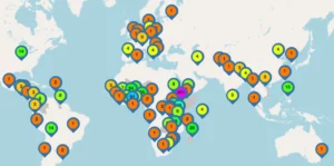
Registered CDT users as of May, 2026 Graphic : Tufa Dinku/SEI
The Climate Data Tool (CDT) was developed under the ENACTS initiative to address one of the most critical challenges facing climate services in many developing countries: the limited availability, poor accessibility, and inconsistent quality of climate data. In many countries, observational networks are sparse, historical station records are incomplete, and climate data are often stored in fragmented or non-standardized formats that are difficult to analyze and use operationally. At the same time, there is increasing demand for reliable climate information to support agriculture, water management, disaster risk reduction, public health, infrastructure planning, and climate change adaptation. CDT was designed to help National Meteorological and Hydrological Services (NMHSs) and partner institutions efficiently manage and quality-control station data, while also generating spatially and temporally complete climate datasets by combining station observations with satellite rainfall estimates and climate reanalysis products.
CDT works by bringing together different types of climate data, mainly weather station observations and satellite or climate model data, and combining them into more complete and reliable datasets. It first checks and cleans station data, then fills gaps using statistical methods and merges it with gridded climate datasets. The result is a set of continuous climate maps and time series that can be visualized, analyzed, and used to generate climate indicators and summaries for practical use.
The main outputs and findings generated using CDT are not stored in a single global repository but are instead produced and used within countries. These outputs typically include national climate datasets, rainfall and temperature maps, drought and rainfall indicators, climate trends, and monitoring products that feed directly into decision-making systems. They are widely used in sectors such as agriculture, water resource management, disaster risk reduction, and climate adaptation planning.
In simple terms, CDT takes scattered and incomplete climate records and turns them into usable national climate information products that governments and institutions can rely on for planning and early warning systems.
The tool is an open-source scientific software package, meaning it is freely available for use in research, operational climate services, and capacity-building. While CDT was initially developed at IRI, its ongoing development and maintenance are now led by scientists at the Stockholm Environment Institute, reflecting a transition in responsibility while maintaining its open-access nature.
CDT is developed and improved through continuous collaboration between SEI scientists and National Meteorological and Hydrological Services (NMHSs) that use the tool operationally. Its methods for data processing, including quality control, interpolation, bias correction, and data merging, are based on established statistical and geospatial techniques commonly used in peer-reviewed climate science. The tool is regularly updated based on user feedback and advances in climate data science to improve accuracy, usability, and performance in real-world applications.
Dinku T, Faniriantsoa R, Islam S, Nsengiyumva G and Grossi A (2022) The Climate Data Tool: Enhancing Climate Services Across Africa. Frontiers in Climate. doi: 10.3389/fclim.2021.787519
The Climate Data Tool: Enhancing Climate Services Across Africa. Dinku Tufa, Faniriantsoa Rija, Islam Shammunul, Nsengiyumva Gloriose, Grossi Amanda. Frontiers in Climate, 2022.
We are working on a web-based version of CDT, which will provide greater flexibility, easier access, and improved usability, while maintaining the core functionality that NMHSs and partners rely on for data analysis, quality control, and validation.
Program / ENACTS transforms fragmented climate data into actionable intelligence, enabling governments and communities to make smarter, climate-resilient decisions.
2026 / About Climate services
Tool / This tool is designed to help users access, manage and analyse data collected from automatic weather stations.
About Climate services
Past event / SEI will contribute to the sessions on climate delivery, adaptation finance and climate communications during Climate Weeks 2026 in Yeosu, Korea.
21 April 2026 / About Climate policy, Climate services and Finance