The Water Evaluation and Adaptation Planning (WEAP) tool supports researchers and scientists alike in water resource planning, providing a comprehensive and user-friendly framework for policy analysis. This story explores how the WEAP software can aid western US states in balancing water trade-offs between both ecosystem and human use.
Sustainable water management is no longer just an environmental goal; it is a social and economic necessity. As governments and communities struggle to balance competing demands, tools like SEI’s Water Evaluation and Adaptation Planning (WEAP) turn complex data into dynamic models that can help planners and policymakers manage water resources more sustainably. WEAP particularly provides value in the drying western US, helping water managers navigate increasingly severe water constraints.
WEAP is uniquely powerful at simulating the different components of a watershed at once, including hydrology, water allocation, supply and demand. WEAP supports a variety of water planning tasks for nearly 60 000 users worldwide, operating as both a water balance database and as a scenario generation and policy analysis tool.
“Serving as a connector of information, WEAP takes the components of a watershed and forces them to interact with one another,” says Doug Chalmers, SEI scientist with over eight years of experience in building water models. “This makes WEAP particularly powerful in evaluating trade-offs between competing water uses.”
Water managers in the western US states often lack the necessary information and tools to make data-informed decisions regarding water rights. Water rights in this region have varied rules for withdrawal limits, user priority, and reporting requirements. Water allocation models built in WEAP can help water managers visualize the complex landscape of water rights, quantify how much water is allotted and simulate the allocation according to the precise water rights legislation.
These models can also provide governments with the necessary scientific basis to inform in-stream flow policies, or regulations that establish the minimum water flow levels in streams and rivers. This information allows policymakers to make sustainable compromises that benefit both farmers and aquatic ecosystems.
Serving as a connector of information, WEAP takes the components of a watershed and forces them to interact with one another. This makes WEAP particularly powerful in evaluating trade-offs between competing water uses.
Doug Chambers, SEI Scientist
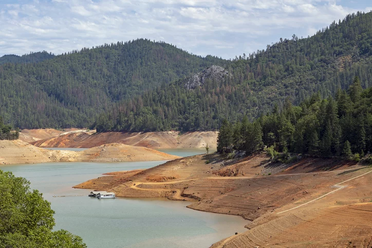
Low water level at Shasta Lake, California, US due to multi-year drought.
The California State Water Resources Control Board is responsible for enforcing water rights and in-stream flow policies. However, achieving this balance is increasingly difficult, as climate change places pressure on state water supplies. Fish populations, most notably salmon, have plummeted to a fraction of historical abundance due to a combination of dam-blocked habitat, low river streamflow, and high water temperatures.
California’s climate is complex, with highly variable weather patterns of wet and very dry years. Consecutive dry years have made it increasingly difficult for the state to allocate water to farmers while still maintaining healthy in-stream flow levels. Aiming to limit stream water shortages, the state created strong streamflow requirements.
Additionally, California also has intricate institutional arrangements between state and local agencies, a profusion of endangered species, and a USD 60 billion-dollar agricultural economy that depends on abundant water resources. These factors all add a layered complexity of trade-offs requiring a sophisticated tool like WEAP to provide a cutting-edge analysis of California’s water resources.
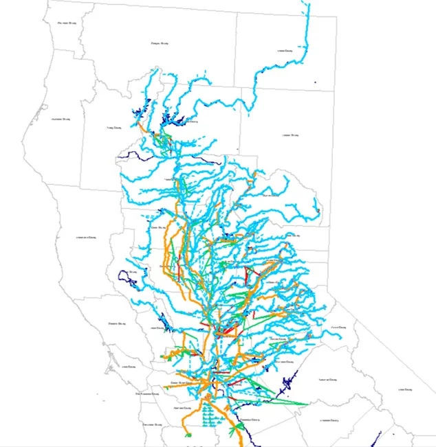
The Water Board partnered with SEI researchers, simulating different policy and climate scenarios in California, such as changes in water allocation rules, flow requirements, drought conditions, climate change impacts, and ecosystem restoration strategies. The model created in WEAP, named SacWAM, (Sacramento River Water Allocation Model), was used to examine both salinity intrusion into the Sacramento-San Joaquin Delta and San Francisco Bay watershed as well as impacts on fish species and habitat conditions. This hub is critical to ecosystems, but also to residents, as it provides water to over 25 million people and 4.5 million acres of farmland.
Using SacWAM, SEI researchers quantified how future management decisions could potentially influence ecological outcomes. This provides the Water Board with evidence that they can present to the California legislature to authorize in-stream flow policies that aim to help protect future fish populations. While it may be difficult to initially tease out the direct impact of water policies, SacWAM allows planners to estimate potential water flows under a variety of regulatory options.
Additionally, the Santa Clara Valley Water District began pilot reservoir re-operations in the Guadalupe River, Coyote Creek and Stevens Creek using the set of FAHCE (Fish and Aquatic Habitat Collaborative Effort) rules to better protect downstream fish habitat. SEI helped develop these operation rules in a collaborative process where local stakeholders developed and tested ideas in a WEAP model.
Image shows the schematic of the SacWAM (Sacramento River Water Allocation Model) in WEAP, showing the major rivers, water conveyances and demands in the Sacramento River watershed across California.
Image: WEAP
On the Olympic Peninsula in Washington state, WEAP was used to help the Dungeness Reservoir Work Group evaluate how a proposed off-stream reservoir could enhance irrigation supply and improve aquatic habitats for endangered species.
The Dungeness Off-Channel Reservoir project was struggling to simulate the water operations of a complex system of agriculture water rights, existing instream policies, and potential future reservoir operations along the Dungeness River. For this reason, local stakeholders tapped WEAP to aid in the process. During the process of constructing the WEAP model, SEI identified existing gaps in the data to resolve with the Work Group. The finished model visually communicated the operations in the basin to the entire Work Group, as well as quantified the expected benefits of the off-channel reservoir to agriculture and fish habitat. The model provided clarity on the operations and their benefits, letting the Work Group refine the operation rules to best balance competing water uses.
By working with the stakeholders to build the model and evaluate the results, we have moved the conversation from wondering what the reservoir benefits might be to now discussing how to best refine the operations based on the quantified estimates.
Doug Chalmers, SEI Scientist
The off-channel reservoir, or a water storage facility, is designed to divert and store water during high-flow periods for later use without blocking fish migration through the river. This allows for more resilient water supply for local irrigation districts as well as protected summer in-stream flow and temperature, as the summer cold water supply from snowpack is expected to decline.
“By working with the stakeholders to build the model and evaluate the results, we have moved the conversation from wondering what the reservoir benefits might be to now discussing how to best refine the operations based on the quantified estimates,” Chalmers says.
By simulating water demand and supply, WEAP is a critical tool for water managers to evaluate operations, management, policy, and infrastructure decisions to best benefit their communities. In doing so, WEAP empowers decision-makers to build resilient water systems that can adapt to future environmental and societal pressures, as implementing balanced decisions is key to facing an uncertain future.
Tool / The Water Evaluation and Adaptation Planning tool (WEAP) provides a comprehensive and user-friendly framework for policy analysis in water resources planning.
Project / The Sacramento Water Allocation Model enables policy-makers to weigh difficult trade-offs in water use, by simulating a complex water system in the US.
Feature / Water managers must balance the needs of aquatic habitat and human supply. SEI Scientist Doug Chalmers explains a new approach to help resolve that tension.
Feature / SEI Senior Scientist Chuck A. Young explains why California saw severe water shortages this year and how better forecasting can help alleviate those challenges.
Vacancy / Support the development of WEAP, one of the world's leading platforms for integrated water resources planning and decision support.