Editor’s choice
Editor’s choice
SEI has completed a 24-month project with UN Environment’s (UNEP) Share the Road Programme to strengthen the technical capacity of African transport planners to develop and implement inclusive climate resilient transport infrastructure. The project focused on the evaluation of participatory approaches and developed an evidence-based toolkit to support African transport policymakers and decision-makers.
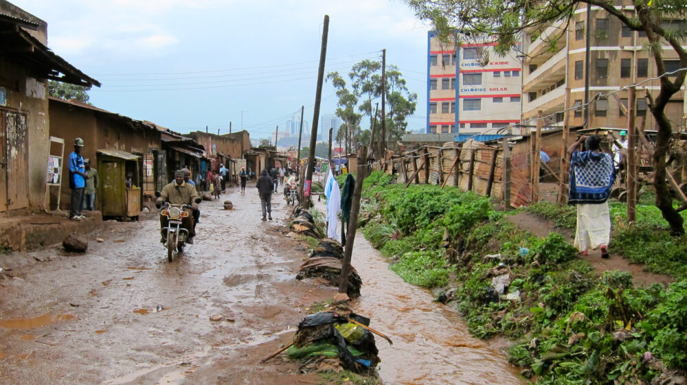
Street panorama, Kampala, Uganda. Photo: Howard Cambridge / SEI.
The Inclusive Climate Resilient Transport Planning in Africa project was funded as part of the UK Foreign, Commonwealth and Development Office (FCDO)’s High Volume Transport (HVT) Applied Research Programme (2020–2022) and was managed DT Global UK.
The research was undertaken by SEI in collaboration with the United Nations Environment Programme’s (UNEP) Share the Road Programme, the Zambia Road Safety Trust, and local consultants in Uganda.
Family having to walk down a busy road due to lack of adequate pavement space in Luthuli Avenue, Nairobi, Kenya. Photo: Howard Cambridge / SEI
The transport sector is the fastest-growing source of greenhouse gases (GHG), and a major contributor to climate change. While many low-income countries (LIC) in Africa currently have low levels of motorization, this is expected to change.
Imported new and used vehicles are increasing by 10% per year in African countries. By 2030, the African car market could reach 1.9 million units, which would represent a modest 1.8% of global sales. However, greater car use in African LIC will mean more polluting vehicle emissions.
Road transport contributes to poor air quality which has an impact on human health such as bronchitis, asthma, heart disease and brain damage. In addition, road traffic deaths are higher in Africa than in any other region of the world.
Climate change will increase the incidence of tropical cyclones, flooding and heatwaves. More extreme weather events will disrupt vital transport infrastructure, networks and services affecting the mobility of low-income disadvantaged groups (i.e. the old, disabled, young, and women).
The provision of transport infrastructure in Africa is often based on political decisions rather than being demand-driven or evidence-based. The standard response to addressing urban mobility issues has been to invest in infrastructure for motorized transport. However, this prioritization of road infrastructure leads to a vicious cycle that stimulates urban sprawl and greater car use.
Inclusion means empowering all people to participate in and benefit from transport. It encompasses transport policies that promote equality and non-discrimination by improving access and mobility of all people, including the poor and disadvantaged, to essential services such as education and health.
The issue of inclusive climate resilient transport is reflected in the United Nations Sustainable Development Goals (SDG) such as SDG 9, aimed at developing resilient infrastructure with a focus on delivering safe, affordable, accessible, and sustainable transport systems, using enhanced participation and engagement in urban planning (SDG 11). This is all within the overarching strategy of tackling the climate emergency (SDG 13), while reducing inequalities (SDG 5 and SDG 10) and eliminating poverty (SDG 1).
However, the key element of the SDG approach is not a focus upon individual targets, but their interconnectivity and indivisibility with the practical challenge of how to deliver an ambitious agenda on the ground. Business-as-usual approaches are insufficient and require transformative changes in policies, funding, actions, and mind-sets.
Congestion at the entrance of Luthuli Avenue, Nairobi, Kenya before it was redesigned in 2019 to create more space for walking and cycling. Photo: Steve Cinderby / SEI.
Poorly planned transport systems have negative consequences for everyone; whether they are driving a car, using public transport, walking or cycling. There is a need to ensure transport planning and decision making is not only sustainable and resilient to climate change but hears the voice of all transport users, especially low-income disadvantaged groups.
Overall, the project’s aim was to contribute to meeting the mobility needs these groups in a changing climate. It set out to address two research questions:
The project sought to strengthen technical capacity in Africa to support the formulation and implementation of inclusive climate resilient low carbon mobility. Creative participatory approaches can incorporate the voice of disadvantaged and low-income groups into the transport planning decision-making process. Therefore, the project focused on the evaluation of these approaches and developed an evidence-based toolkit to support transport policymakers and decision-makers.
The specific objectives of the project were to:
The project increased:
People using a 3D zebra crossing in Lusaka, Zambia in 2021. Photo: D Mwamba / ZRST
Creative participatory methods for urban transport planning enable participants to visualize, share experiences, explore different possibilities, and challenge current thinking.
They encourage engagement from often hard-to-reach, vulnerable participants through on-street activities or novel co-designed approaches, enabling their voices to be heard in transport policy-making and planning processes.
However, implementing creative and participatory approaches requires a change in how transport consultation, planning, and decision‐making is undertaken.
While increasing inclusion and participation may appear time‐consuming compared to conventional consultation activities, it can enhance the quality of information used to make decisions. As a consequence this should result in more inclusive and equitable outcomes that may, in the medium‐term, turn out to be more robust, cost‐effective, and sustainable.
Narratives – Combines storytelling or image creation (photos, art canvases, etc.) that communicate participants’ stories of the future. These approaches can identify specific local contexts and cultural factors that affect planning and infrastructure developments, including existing effects of climate change. They can be used on street, in meetings and can facilitate participation over a longer timeline.
Digital stories – These include photo‐voice (where participants take their own pictures to illustrate their personal situation); documentary photography (where professional photographers take images to communicate someone else’s experiences); and participant‐directed video tours that explore community knowledge.
Participatory mapping – These are methods that collect information from participants in a spatial framework (a paper or digital map). The information can include their knowledge of local mobility. Maps are used to identify locations where residents found particularly challenging and where solutions could be implemented.
Streetscape models – Participants interact with streetscape models (3D representations of the locality) to identify current mobility challenges or to suggest infrastructure improvements. They are engaging and interactive, encouraging widespread participation.
Placemaking activities – These are practical interventions for transforming public spaces to improve mobility choices, road safety and climate resilience. Within these activities, there are opportunities to undertake experiments with infrastructure. These can include the temporary closure of streets to motorised traffic to explore safety and active travel options; or utilising the streetscape for alternative community or economic purposes (for example, recreation spaces and/or cafés or on-street vendors).
Infrastructure experiments – These are temporary changes to infrastructure to encourage a behaviour change typically to improve safety, encourage modal shift, or identify unexpected impacts of a proposed scheme before full permanent implementation. These sorts of interventions are useful as they can be removed or installed in new locations to maintain the ‘surprise’ element for vehicle drivers.
Deliberative approaches – Useful for deciding on future strategies among a range of options or to work towards a consensus on disputed topics. The Delphi method is an example of a deliberative approach.
Namirembe Road, Kampala Road now has dedicated lanes for non-motorized transport (NMT). Photo: Howard Cambridge / SEI
The HVT project undertook the following key activities:

HVT Case Study – Tokyo Way – Kamwala South, Lusaka, Zambia. On-street survey and PGIS mapping.
Photo: Daniel Mwamba / Zambia Road Safety Trust.
The majority of trips in Lusaka consist of walking, followed by public transport, and with only 10% trips by car. Despite low car ownership, Lusaka and other Zambian cities are experiencing increasing traffic congestion, road fatalities and poor air quality making it difficult for disadvantaged groups to access economic and educational opportunities. To overcome such challenges and reduce greenhouse gas emissions, cities need to adopt urban planning strategies and transport system interventions that promote a shift to low carbon modes, including efficient public transport, walking, and cycling.
The Zambia Road Safety Trust (ZRST) tested new ways of working with local people to better understand their journeys, the road safety risks they experience, climate change impact and also their ideas on solutions of how to improve local travel.

HVT-On-street Engagement with different road users. Photo: Daniel Mwamba / Zambia Road Safety Trust.
This location has been identified as one of the most unsafe road traffic junctions in Lusaka, particularly for a large number school children during their travel to and from school. The junction also affects the safety of other vulnerable road users.

Participatory Geographic Information System (PGIS) Mapping used as a creative method for engagement on the street. Photo: Daniel Mwamba / Zambia Road Safety Trust.
This case study assessed the experiences of disadvantaged groups who use the Tokyo Way/Kamwala South road junction. It determined what challenges they face and how these impact their mobility and transport mode choices, especially during different weather conditions. It also examined using creative and participatory methods to gain additional insights to mobility needs of disadvantaged groups to provide a more inclusive transport planning process, and one that also considers future climate change.
The case study investigated using Participatory Geographical Information Systems (PGIS) and pop-up creative activities to gain insights into the mobility challenges and needs of disadvantaged road users.

HVT Lusaka Case Study – PGIS mapping. Photo: Daniel Mwamba / Zambia Road Safety Trust.
Artworks; streetscape models; digital story-telling and photography were used to capture local knowledge and identify co-created solutions and preferences for mobility infrastructure.

The on-street activities were featured on Zambian TV. Photos: Daniel Mwamba / Zambia Road Safety Trust.
Feedback from stakeholders helped identify the key problems of road safety and climate change in this area which were communicated to Lusaka City Council and other central government agencies responsible for transport planning. This also provided the evidence to support the development of the Guidance Document to promote inclusive climate resilient transport in African cities.
Interview with Daniel Mwamba (Zambia Road Safety Trust) on the on-street mapping exercise for the case study.
On-street survey July 2021
Lusaka City Council (LCC) granted permission to ZRST to undertake the case-study . The first on-street survey took place in July 2021 using rapid PGIS mapping. More than 40 participants were asked about their typical daily journeys and their perceptions of road safety, climate impacts and ideas for solutions to the problems. Further surveys and stakeholder engagement activities using different creative methods will take place around the junction.
The case study in Kampala assessed the impact of implementing a “Boda Boda Free Zone” on disadvantaged groups, by using creative methods to engage riders and passengers. It also sought to understand how climate change and air pollution affects the journeys people take.
The case study aimed to strengthen the technical capacity to support the formulation and implementation of more inclusive climate resilient low carbon mobility in the city through close collaboration with the Kampala Capital City Authority.
Boda Bodas (motorcycle taxis) are a common means of public transport used in Uganda and especially in the capital city of Kampala. They are a source of livelihood for young people, convenient and cheap for users, and avoid traffic congestion. Unlike other public transport services, Boda Bodas provide accessibility to nearly all areas of the city. There are currently an estimated 120,000 Boda Bodas operating in Kampala City. Their name originates from the “border-to-border” rides between Uganda and Kenya in the 1960s and 70s.
The Boda Boda Free Zone, was proposed by the Ugandan government during the COVID pandemic first and foremost as a safety and public space quality improvement measure. Other measures to regulate Boda Boda riders included their registration at stages (pick-up points) and through the use of apps e.g. SafeBoda.

Boda Boda motorcycle taxi in Kampala, Uganda. Photo: banzaye/pixabay
Boda Bodas may pose a threat to the health of non-motorized transport users, as they are a source of air pollution and exacerbate road safety problems in Kampala’s mixed traffic. While the ban on them may have benefits for road safety, public space, climate and air quality, conversely, it could also have negative impacts on the livelihoods of youths, as well as reducing mobility options of poorer citizens who rely on Boda Bodas. It may also result in concentrating the Boda Bodas elsewhere, at unofficial stages; therefore, simply shifting the issue.
Based on a decision by the Cabinet of Uganda, on 25th July 2020, a proposal was made to restrict access by Boda Bodas to Central Business District of Kampala.

Kampala Boda Boda Free Zone map. Image:: KCCA
Various data collection methods were used in the study to gain different perspectives of the mobility challenges faced by road users (service providers and disadvantaged groups) following the establishment of the Boda Boda Free Zone. These include: on-street interviews, field observations, participatory mapping, scenario and visioning (Delphi approach) and digital story telling.
Different stakeholders were consulted about their opinions on mobility issues in Kampala; the impact of the Boda Boda Free Zone; and how climate affects their Boda Boda usage. Stakeholders included: motorcyclists, passengers, planners, decision makers, civil society organizations, and disadvantaged group representatives.

Street interviews being conducted on Namirembe Rd, Kampala, Uganda. Photo: H Cambridge/Alon Mwesigwa
Mapping was used to record the locations of Boda Boda motorcycle stages used by passengers and to identify the principal routes they take. This helped identify the busiest areas of the Central business District (CBD). The map is also used as a tool to capture how people visualize the CBD without the motorcycle taxis.

PGIS Map from Namirembe Road engagement. H Cambridge/i-CMiiST
Using collaborative processes, participants and facilitators worked together to produce powerful stories about mobility challenges facing vulnerable road users. Digital media (photo, video, audio) was used to document, highlight and explain the lived experience of different road users, providing insights into issues that would have otherwise been inaccessible using traditional interview methods.

Using creative methods to capture user journeys using Boda Bodas from different perspectives. Photo: H Cambridge / i-CMiIST
Representatives from disadvantaged and vulnerable groups produced short digital stories highlighting the routes they usually took, describing the personal difficulties they experience on a daily basis. Presenting their stories enabled them to propose solutions as well.
In addition, cameras were used to observe the traffic situation in Kampala from the perspective of the Boda Boda riders themselves. Selected riders had cameras mounted on their motorcycle to record their journey over a set route.

On-street interviews with Boda Boda drivers in Kampala, Uganda. Photo: H Cambridge / i-CMiiST
This is an approach to decision-making that allows participants to consider relevant information from multiple points of view. The case study utilized the Delphi method approach, developed by Rand, where a pool of experts considered a number of statements about the extent to which transport infrastructure is affected by climate change. Over a series of iterations, a facilitator compiled the responses, refined the statements and returned them back to the experts until a final consensus was reached.
Finally, the case study compiled supplementary information pertaining to the Boda Boda Free Zone from regulatory agencies responsible for planning and implementing transport policies in the city including: Kampala Capital City Authority, National Road Safety Council, Ministry of works – (Transport Licensing Board), Uganda Police Force ( traffic directorate, vehicle inspection) and the National Planning Authority.
| UNEP Share the Road | Uganda Local Partner |
 Carly Gilbert-Patrick, Share The Road, UNEP Carly Gilbert-Patrick |
 Amanda-Ngabirano, Makerere University, Uganda. Amanda Ngabirano |
| Zambia Local Partner | Uganda Local Partner |
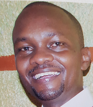
 Daniel Mwamba, Zambia Road Safety Trust.. Daniel Mwamba Daniel Mwamba is the founder and chairman for Zambia’s leading NGO for Road Safety, the Zambia Road Safety Trust. He is also the country’s Data Coordinator for the WHO Road Safety Global Status Report. |
 Wasike Yusuf Arby Wasike Yusuf Arby Wasike Yusuf Arby is an Urban Planner and Managing Partner of Newsphere Innovations Limited. |
Other publication / This guidance document summarizes key concepts around transport inclusion, participation, and climate change and provides novel tools for increasing engagement.
Perspective / This perspective highlights three major solutions to address the challenges faced by low-income and vulnerable transport users in African cities.
Other publication / Understanding the challenges of inclusivity and climate resilience in transport planning in Africa: results of a needs assessment in 4 countries.
Project / Implementing Creative Methodological Innovations for Inclusive Sustainable Transport Planning (i-CMiiST) explored creative co-design methods for safer streets.
Feature / At the Eastern Africa Women in Transportation Conference, SEI joined employees and policy-makers to discuss how to create an inclusive public transport sector.
Feature / Non-traditional urban planning tools – think art and poetry – underpin new ways of co-designing city infrastructure to address health and mobility issues.