Editor’s choice
Editor’s choice
The shared Meghna River Basin’s vital wetlands have shrunk by over 50% since 1994, threatening ecosystems and communities. AI-powered monitoring now offers real-time insights to reverse this loss and drive urgent conservation action.
In 1994, wetlands once covered about 22 percent or approximately 105,700 hectares (ha) of the shared Meghna River Basin (MRB) in Bangladesh and India. But in 2024, wetlands barely spread over 9 percent or about 44500 ha. These ecosystems consist largely of seasonal floodplain depressions known locally as haors. Within them lie deeper, perennial water bodies called beels. These wetlands sustain regional biodiversity, provide food and water storage for millions in both Bangladesh and India, and buffer floods. Yet they are disappearing rapidly due to climate change, pollution, and unsustainable resource exploitation. The loss disproportionately affects women, smallholder farmers, and Indigenous communities who rely on these ecosystems for their livelihoods.
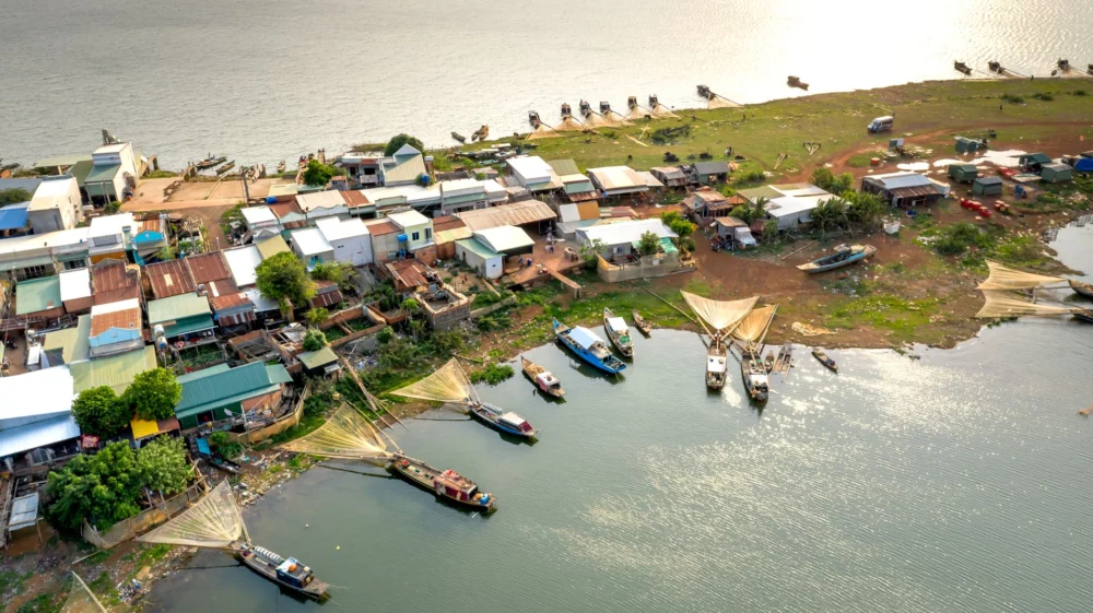
View of haor wetland in monsoon from MRB. Photo: Satish Prasad / SEI Asia.
Traditional ground surveys struggle to monitor such dynamic landscapes often due to resource and logistical constraints. Outdated or insufficient data poses challenges to conservation planning and implementation.
Artificial intelligence (AI) offers innovative solutions by swift processing of remote sensing data—like multispectral satellite imagery, hyperspectral scans, and drone footage. AI now enables accurate, real-time monitoring of complex wetland ecosystems, from forests to marshes, mangroves and floodplains. Machine learning models detect shifts in surface water extent, vegetation cover, sedimentation, and pollution levels with high spatio-temporal resolution.
This allows policymakers, managers, and communities to visualize changes and take proactive measures. AI scenario engines also enhance flood predictability, improving disaster risk resilience and decreasing loss of life and property. Importantly, AI can model how climate, development, and governance decisions may impact wetland health.
By strengthening open data access, AI-led climate data platforms can significantly enhance local planning and build the capacity of frontline agencies, but only when grounded in community-led knowledge.
Gaurav Godhwani, Co-founder and executive director at Civic Data Lab, India
SEI’s interactive portal Asia River Monitoring offers remote sensing tools for rivers, coasts, and wetlands. The key tools include:
All cloud-based tools feature low maintenance costs and user-friendly interfaces for data visualization and download.
Wetlands extent in the Meghna River Basin using the Wetland Monitoring Tool developed by SEI.
Decline in the MRB wetland area (1994 to 2024).
Over 30 years, wetland areas declined from >200,000 ha (early 2000s) to 150,000 ha (2024), showing the need for real-time wetland monitoring.
AI is enabling large-scale spatial monitoring with unprecedented speed and accuracy. Advancing AI tools will empower governments and communities to protect the Meghna Basin’s wetlands, and others around the world, before these ecosystems disappear forever.
Dr Thanapon Piman, Senior Research Fellow in SEI Asia
Indigenous and local communities have a deep understanding of the MRB’s floods pulses, fish migrations, and crop cycles. Involving them as co-producers of AI- tools improves accuracy, transparency and inclusivity. As SEI’s work in Assam, India, revealed, merging technology with citizen science is key towards building flood resilience.
“Forecasting erosion or flood risks can save lives and livelihoods. For us, early warning is critical,” said a floodplain farmer in Suapata village, Assam, India
SEI researchers talking to the local community about seasonal floods and riverbank changes, Suapata village, Dhubri district, Assam, India. Photo: Satish Prasad / SEI Asia.
The Meghna River Basin spans India and Bangladesh, making upstream threats into downstream crises. Joint AI-driven flood and habitat models can build trust, improve flood-warning lead times, and coordinate wetland conservation.
Vishwa Ranjan Sinha, Senior Programme Officer of IUCN, Asia, said: “The Barak-Meghna Basin faces rising temperatures (+0.07°C per year), erratic rainfall patterns, and wetland degradation. Integrating AI with nature-based solutions will support climate resilience for millions.”
Protecting the Meghna’s wetlands is an ecological, social and economic necessity. To ensure that AI is integrated responsibly:
As a shared river basin, the MRB’s challenges require shared solutions. Siloed responses will fail. Cooperation, community-driven action, and AI-powered tools can pave the path to effective wetlands conservation.
This piece was developed under the Transboundary Rivers of South Asia (TROSA) Phase-2: Rivers, Rights, and Resilience (T2:3R) project implemented by SEI and Oxfam Novib, and funded by the Swedish government.
Program / This 4-year program aims to foster stronger cooperation in managing shared water resources and building resilience among riparian communities.
Event on 22 July – 23 July in Bangkok / Join SEI experts at Mekong Forum 2026, featuring the technical sessions, exhibition, and innovation pitches.
Past event / SEI and Mekong Institute (MI) will renew their shared commitment for sustainable development and climate resilience in the Mekong Region.
Perspective / Collaborative and multi-benefit approaches with nature-based solutions can help build a resilient, equitable water future for the Mekong Region.